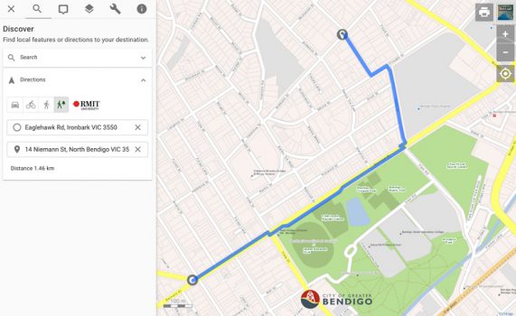
With the mercury recently hitting 45C in Bendigo, Council has adopted a new tool which helps residents seek out routes with the most shade coverage and avoid the heat.
The Shadeways tool, developed by researchers from the Royal Melbourne Institute of Technology, uses satellite imagery to generate a “temperature likelihood” monitor.
By analysing surfaces and vegetation type, it creates an urban heat map and generates suggested shaded routes.
It’s currently a web-based browser that uses an open source mapping system, but developers of the program are hoping to eventually pair it with popular navigation apps such as Google Maps and Apple Maps.
The tool was launched as a prototype for the City of Bendigo in December as part of the government’s Smart Cities and Suburbs Program.
Unless we start to deal with the urban heat issue … it seems likely that, particularly for vulnerable groups, our cities are going to become quite unliveable – Professor Andrew Butt.
Mayor of Bendigo Margaret O’Rourke says the City has been experiencing extreme temperatures of over 45 degrees.

“We’ve got some beautiful shady trees in our area and in a number of our suburbs,” she told Government News.
“So it’s a tool that people can use when they are walking or riding, that they’ll be able to see the cooler routes for them to use.”
Clr O’Rourke says Council aims to turn Bendigo into one of the world’s most liveable communities, and she believes the mapping tool will help achieve this goal.
“I know myself, when you’re walking somewhere, you’re always looking for which is the shadier side of the street on a hot day,” she said.
“And if people are actually travelling somewhere and they’re going to be walking, they can actually hop on and have a look and they can see where the most shaded areas are, and I think that’s a real benefit in terms of the liveability.”
Andrew Butt, co-investigator on the Shadeways project and Associate Professor in Sustainability and Urban Planning at RMIT, says it’s important to factor in shade as climate changes.
“We’re in one of the hottest years we’ve ever seen in Australia and people’s mobility in the city, particularly vulnerable groups’ mobility in the city, is very much dependent on their access to shade,” he told Government News.

Importance of shade infrastructure
He is also hoping the tool will draw attention to the importance of shade infrastructure in urban planning.

“It’s a two way process. It’s a route planning tool for people who actually just want to go somewhere but it’s also a tool for thinking about infrastructure spending and the politics of raising awareness of shade as a desirable piece of urban infrastructure.”
Professor Butt says councils can also use the tool in their urban planning to work out where shade-rich areas are and find places that are shade-vulnerable.
“That doesn’t mean you plant everywhere, but it does mean you start to think about how you improve the quality of those environments,” he said.
Dealing with urban heat issue is crucial, Professor Butt says.
“Unless we start to deal with the urban heat issue and some urban green issues, it seems likely that, particularly for vulnerable groups, our cities are going to become quite unliveable,” he said.
“And we know that we’re losing urban greening, particularly in the private realm, so this situates in the greater picture of urban clean air and landscapes that results from that.”
The Shadeways team currently has an application for a grant that will involve several local governments, including the City of Bendigo, to try and further develop the tool to look at how people understand shade and what they value about it.
Shadeaways is supported by Greener Spaces Better Places, which is helping to increase and improve green spaces in Australia’s towns and cities.


Leave a Reply