
The South Australian Government will use the SA-built Kanyini space satellite to monitor temperature and vegetation in Adelaide and regional areas of the state.
Using data captured by Kanyini, which is set to be launched into orbit this month, the SmartSat CRC-led research will pilot ways in which government agencies can use thermal sensing and biodiversity mapping to protect the environment and prepare for heat events.
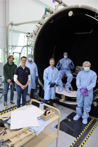
Kanyini is Australia’s first state-based satellite.
SmartSat CRC CEO Professor Andy Koronios says up till now images of the state have been sourced from foreign satellites, limiting access up-to-date, detailed images of areas of local interest.
“With the Kanyini mission, we are demonstrating the capability to capture images of specific locations tailored to particular applications,” he said.
“By leveraging advanced data analytics, we have the ability to transform these images into actionable intelligence for state government departments for the benefit of all South Australians.”
Planning for heatwaves
One project will create heat maps of surface temperatures across Adelaide and some regional areas, and analyse how this can enable better planning and responses to heatwaves.
The government says the project will test how the technology can be used for infrastructure planning, resilience and mitigation strategies, and green investment decisions.
The second project will use Kanyini’s hyperspectral imagery combined with AI-based analytics to monitor native vegetation cover and crop health, focusing on Kangaroo Island and the Northern pastoral region.
The data will provide insights into land-use and plant species that are important for carbon sequestration.
“This has the potential to provide vital insights for farmers and pastoralists to monitor and understand vegetation changes as well as forecast the ecological impacts of future climate conditions,” a government statement says.
Unprecedented opportunities
About the size of a cereal packet and weighing only 12kg, Kanyini will be positioned in low orbit about 500km above the Earth.
Space data has the potential to unlock unprecedented opportunities to understand and protect the environment, South Australian Space Industry Centre Chief Executive Matt Opie said.
“The Kanyini satellite exemplifies this potential, and these projects will provide critical insights derived from space to help our experts on the ground make informed decisions to tackle environmental management and sustainability challenges.
“Our partnership with the SmartSat CRC marks a significant milestone in utilising space technology for environmental benefits here on Earth.”
Kanyini, a Pitjantjatjara term describing the “principle of responsibility and unconditional love for all of creation”, is set to be launched into orbit onboard SpaceX Transporter 11 in July from the Vandenberg Space Force Base in California.
After an expected three-year lifespan circling the globe, the satellite re-enter earth and burn up.
The South Australian Space Industry Centre, based in Adelaide’s Lot Fourteen innovation precinct, was created by the South Australian Government as a home to the Australian Space Agency.
Leave a Reply