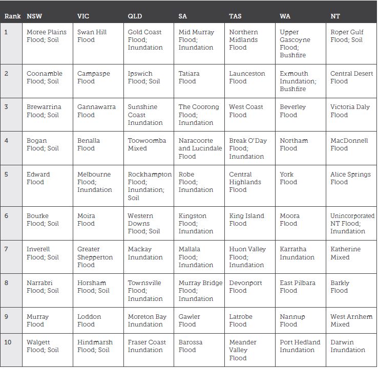
Gold Coast, Moree Plains in NSW and Victoria’s Swan Hill top the list of Australian Local Government Areas most affected by floods, inundation, bushfire or soil erosion.
Mid Murray in South Australia, Northern Midlands in Tasmania, Upper Gascoyne in WA and the Northern Territory’s Roper Gulf round out the list of the ten most climate-change affected LGAs in every state and territory, based on the percentage of properties at risk of damge.
The list, contained in a Climate Council report on the cost of climate change to the Australian Economy is based on LGAs with the highest number of properties that are highly exposed to current and future hazards including flooding, bushfires and coastal inundation.
Queensland has the highest percentage of impacted properties overall, with a “disproportionate number of LGAs that will be highly impacted by climate change and extreme weather” the report says.
According to Climate Council projections, sixty-four per cent of Queensland LGAs will have 10 per cent or more of their properties facing an “effectively unaffordable” insurance cost by 2100.
Next is NSW with 28 per cent of LGAs affected and the NT with 24 per cent.
A spokesman for LGAQ said the findings weren’t surprising and Queensland councils had learnt to be pro-active in adapting to challenges.
“Queensland councils have been at the forefront of climate change adaptation for several years,” he told Government News.
The report says by 2030 about one in 19 Australian properties is expected to experience average annual insurance risk costs that are effectively unaffordable, or the equivalent of one per cent or more of the property value per anum.
That’s projected to grow to one in every 15 properties by 2100.
The Climate Council says these figure are conservative, and don’t take into account new properties built in areas exposed to current and emerging climate change risks.
Climate risk scientist Dr Karl Mallon said historically councils have held the most information about climate change related risks in the form of flood and bushfire maps, but this is changing as more granular information becomes more widely available to other entities.
“Essentially we’re going to see now a lot of property owners in business or residential starting to ask some hard questions about what councils are doing to proptect their properties. The days of sitting back and doing nothing are over,’ he told Government News.
Dr Mallon says councils will find themselves dealing with a new paradigm which could involve buybacks, legal cases or demands for action like the erection of sea walls.
“We’re in unchartered waters and councils are going to be in the thick of it,” he said.
Table of the top ten most impacted LGAs in each state and territory

Call for action
The report comes after Mayors representing Australia’s local government climate alliance last week issued a joint call for national action to tackle climate change, saying the states and commonwealth must support local solutions.
In a joint statement issued last Wednesday, fifteen mayors from the Cities Power Partnership, a program created by the Climate Council to support the switch to clean energy by towns and cities, called on the federal government to join them in making climate change a top priority.
“All tiers of government have a role to play in driving down Australia’s greenhouse gas pollution, and we need swift action at the federal level to address our escalating national emissions,” they said in a statement.
Comment below to have your say on this story.
If you have a news story or tip-off, get in touch at editorial@governmentnews.com.au.
Sign up to the Government News newsletter.


Leave a Reply